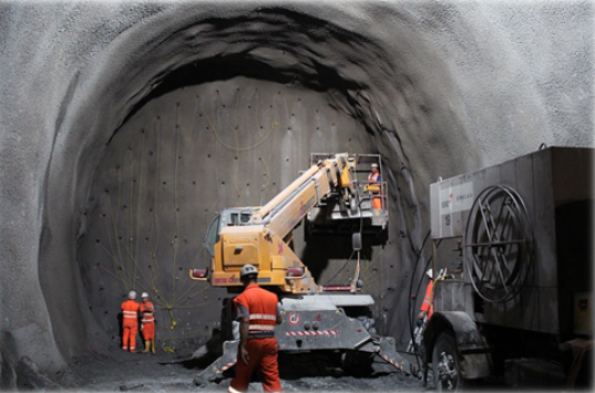
Ensuring the safety of workers inside confined spaces is a critical activity in the field of construction and maintenance because of the high risk involved in working in such environments. Perhaps it would be useful, first of all, to know what is meant by confined spaces. There are two main types of confined spaces: the so-called ‘open’ ones, which are those with an opening in their upper part and of such a depth that it makes their natural ventilation difficult (vehicle lubrication pits, wells, open tanks, tanks),…) and ‘closed’ ones with access openings (storage tanks, underground transformer rooms, tunnels, sewers, service galleries, ship holds, underground manholes, transport tanks, etc.). Workers entering these confined spaces are exposed too much greater risks than in other areas of construction or maintenance and it is therefore essential to apply extreme caution.
Each confined space has specific characteristics (type of construction, length, diameter, installations, etc.) and specific associated risks, which means that they require solutions that are highly geared to their specific safety needs.
The ‘conventional’ risks specific to confined spaces are mainly oxygen suffocation, inhalation poisoning of pollutants and fires and explosions. But new ’emerging’ risks from exposure to new building materials such as nanoparticles and ultrafine particles are also emerging. In addition, as research into new materials improves, there is also a better understanding of their potential negative effects on human health and how to prevent them.
The truth is that the training of workers and current safety regulations seek to anticipate risk situations before they occur in order to avoid them and thus prevent the appearance of accidents. But several problems arise: on the one hand, the regulations are not always strictly observed (whether due to workload, carelessness, fatigue, etc.) and on the other hand, there are always inevitable risks. In the case of carelessness, systems can be proposed to minimise this type of error and in the case of risks that cannot be avoided, systems can be proposed to detect them early and plan the corresponding action protocols.
It should be noted that risk situations do not usually appear suddenly and in most cases are detectable in time to avoid personal misfortunes. There are several problems: the detection of these risks is usually done with specific measurements using the portable equipment that the workers must carry, many times the workers are not controlled to access the premises with the corresponding protection equipmente and almost never a continuous monitoring of the indoor atmosphere is done.
In recent years, new technologies and equipment have been developed that can be applied to improve security in this type of environment and reduce the associated risks.
In this type of environment, an effective risk prevention system should be based on technological solutions capable of providing answers to safety aspects throughout the entire work cycle in confined spaces: Before entering the space itself, during all work inside the enclosure and when leaving the work space (whether it is at the end of normal work or by evacuation).
The latest confined space air quality monitoring systems are based on multisensorial technology that combine different detection systems to ensure the best possible conditions to avoid or reduce the risks present in the confined spaces.
Advanced data processing techniques (machine learning, data mining, predictive algorithms) are also being applied, enabling much more efficient and rapid information extraction.
In the same way, great advances have been made in access control and personnel tracking systems, allowing us to know the position of each worker and even his or her vital signs in order to detect almost immediately any problem that may arise.
Finally, it should be noted that the use of robots and autonomous vehicles (land and air) equipped with different types of sensorization are increasingly being used to determine the conditions of a site before it is accessed. This is especially useful in those where there may have been an incident: power failure, collapse, fire,… or simply because environmental conditions are suspected to have changed and the reason is unknown.
CARTIF has been working on these issues for many years now, both in safety projects in critical construction environments (PRECOIL, SORTI) and in specific systems for tunnels and underground works (PREFEX, INFIT, SITEER).
In short, the development and implementation of new specific technologies can help to save lives in such a critical environment as confined spaces.
In two previous blogs of ‘When the Historic Buildings Talk’ (2)and(3), we have described how does affect and what is the importance of monitoring temperature and humidity as well as lighting (natural and artificial) in historic buildings. To complete this saga of pernicious aspects, the turn to the pollutants is open just now.
We all know, and suffer, that the composition of the air is altered by compounds that come mainly from the use of fuels (road traffic and heating) and industrial activities. These pollutants can trigger chemical reactions in the materials that make up the cultural assets (movable or immovable), degrading them to a greater or lesser extent. The pollutants with the highest concentration in the exterior are sulphur dioxide (SO2), oxides of nitrogen (NOX), ozone (O3) and suspended particles (PM). In addition to these pollutants that “travel free” throughout the air outside the buildings, there are others to be taken into account inside them, such as vapors of organic compounds (COV), products used in conservation and restoration tasks, and even human presence.
Again, we have to ask ourselves: what are their effects? Here it is a short description of the main ones:
SO2 is related to coal combustion and to industrial activities and transportation. It causes metal corrosion, pigment discoloration, weakening of leather and acidification of paper.
Among the NOx, the nitrogen dioxide (NO2) needs to be highlighted. It comes from combustion in vehicles and in industry, and associated effects are the discoloration of pigments and the contribution to the degradation of paper and leather.
The renowned ozone (O3) is naturally present in the stratosphere. This is a good point, because it protects us from malignant solar radiation, but at ground level is linked to road traffic and intense solar radiation. It causes the degradation of natural gums and the discoloration of pigments.
PM are characterized by their diameter, distinguishing between fine particles (PM 2.5: with diameter equal to or less than 2.5 μm), and coarse particles (PM 10: with a diameter between 2.5 μm and 10 μm –keep in mind that 1 μm is one-millionth of a meter-). The fine ones affect the discoloration and dirt of the surfaces. On the other hand, coarse ones contain highly reactive compounds (e.g. residues from incomplete combustion of road traffic). The dust enters this section: apart from its obvious aesthetic impact (denotes sloppiness and lack of care) can lead to chemical deterioration, and can serve as a habitat for insects (do you get bit?…)
In general, the study of outdoors pollution is more developed and legislated than the indoors one. However, in the field of Cultural Heritage, the study of indoor air quality is very important because of the logical conservation demands. Following once again the criteria of the IPCE, which establishes the Spanish National Preventive Conservation Plan (PNCP), these are the evaluation parameters of the risks derived from the pollution to which the historic buildings are exposed:
External parameters:
Medium where the cultural asset is located (rural, urban, industrial, coastal, etc.).
Polluting sources nearby, whether of anthropogenic origin (industrial and transport processes) or of natural origin (volcanoes, fires, sea water, animal life, vegetation, etc.).
Meteorological factors such as winds and precipitations that influence the dispersion and deposition of pollutants.
Internal parameters:
Sources of indoor pollution.
Quality of the external air and location of the asset in relation to the exterior.
Waterproofing of the building, its compartments and furniture.
Distribution of pollutants by air circulation.
Already existing air conditioning, heating and ventilation facilities, as well as their use and maintenance.
And, these are the criteria that must be taken into account for the assessment of the deterioration produced by the pollutants:
The pollution damage is cumulative, so very low limits needs to be set depending on the detection ability of available devices.
The damage is determined by the dose, i.e. the concentration of the contaminant (in μg/m3 or parts per billion -pbb-) by the exposure time. This exposure time is conveniently estimated to take into account the overall effect.
Keep in mind the mutual influence between pollution and other already known factors, such as humidity and lighting.
In conclusion, the air quality inside and / or outside the built heritage defines its conservation (see Figure). Let me remind you again that CARTIF is ready to advise you, to help you and to offer solutions tailored to your needs. You can have a look to some projects: RESCATAME, SHCITY and EQUINOX. We have been innovating in Natural and Cultural Heritage for more than 20 years. At your disposal!
In a previous post the social and economic importance of heritage conservation were already described. Also we promised that on successive posts we will go into more detail describing the three main aspects that need to be monitored to ensure such conservation. Refreshing your memory, they were:
Relative humidity and temperature.
Lighting (natural and artificial).
Contaminants.
As promised is debt, in this post we will focus on the first point (be patient, we will talk about others further on), which makes us to face the heritage “bad boys”. Relative humidity and temperature are very damaging in the effects they can cause on the materials of which historic buildings are made of. Taking advantage of Physics, relative humidity is a very useful indicator of the water content in the air (vapour), and, on the other hand, temperature indicates the level of kinetic energy (movement) of the molecules of the air.
Both parameters vary according to the local meteorological conditions, the human actions and the conservation state of the historical buildings. This means that the atmosphere surrounding the historical buildings consist of a greater or lesser amount of water vapour at a certain temperature, definitely influencing the physical & chemical stability of the materials of which they are built on, or even of which the objects inside are composed.
In this sense, it is not negligible the effect caused by people, not only by our increasingly demanding comfort requirements, but by the number of visitors. We can influence the relative humidity and the temperature in such a way that inadequate values are reached. The effects of people are added to those of the local climate (more or less wet or warm), to the assets by itself (watertightness and ventilation capacity), to the derivatives of the proximity of heat sources (heating, sunny glass surfaces, old artificial lighting systems), the proximity of cold sources (external walls or air conditioning systems), as well as sources of humidity (leaks and floods).
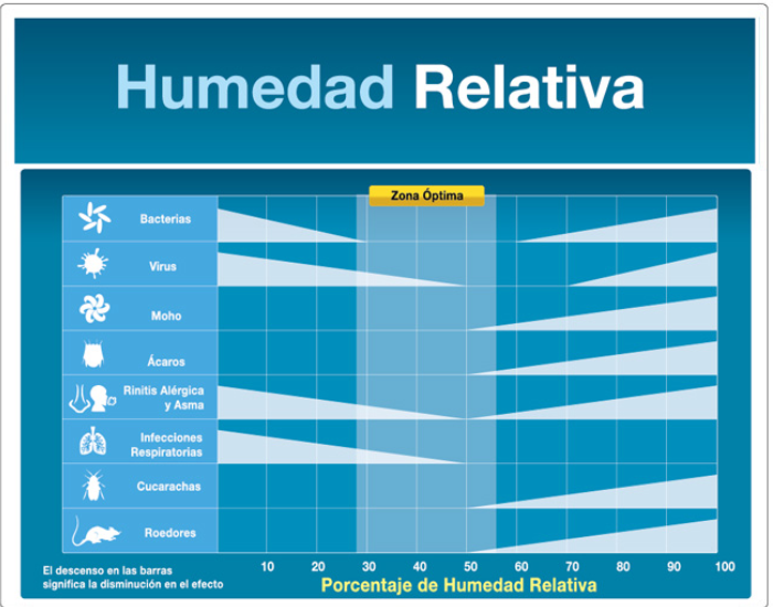
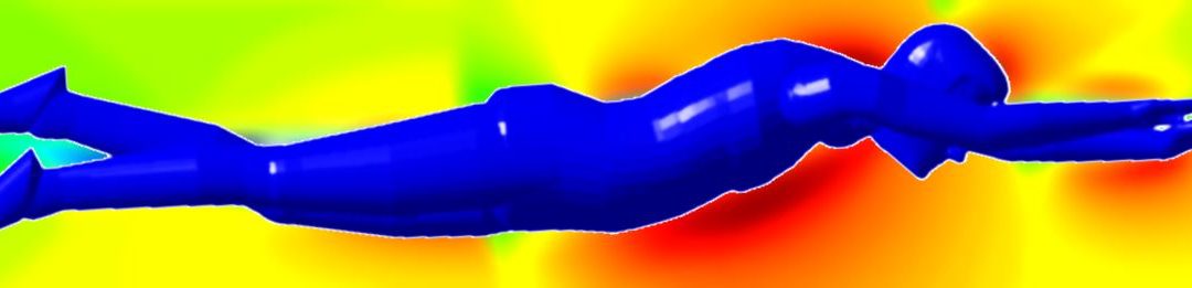
The main factor to be controlled because the risk of direct deterioration that could originate is just humidity. The amount of water vapour in the air results in dimensional changes such as the well-known expansion and contraction of wood, making fractures and cracks when strong fluctuations happen. In addition, extreme relative humidity values cause softening or drying of organic materials such as adhesives and binders. But it also affects the stability of inorganic materials, such as metals, accelerating the corrosion processes, especially in the presence of salts. In poorly ventilation and dirty conditions, high values of relative humidity will cause the proliferation of living organisms causing biodeterioration (from microorganisms to rodents … Disgusting!). Even health problems as shown in the image.
Conversely, the temperature accelerates the chemical reactions and favours the biological activity. It contributes to the softening of waxes and adhesives and the loss of adhesion between different materials, such as enamels.
Perhaps reading all this causes some discomfort (and even itching …). But, what can we do to prevent these adverse effects? The answer is as simple as reasonable: just avoiding too high or too low levels of temperature and relative humidity, ensuring the highest possible stability
Following the indications of the IPCE (Spanish Cultural Heritage Institute, dependent on the Ministry of Culture), which establishes the National Preventive Conservation Plan (PNCP), the evaluation of risks derived from the microclimatic factors of which we are talking about, three aspects must be monitored:
Extreme levels of relative humidity and air temperature.
The magnitude and speed of fluctuations in relative humidity and air temperature.
The proximity of sources of humidity and heating or cooling emission sources.
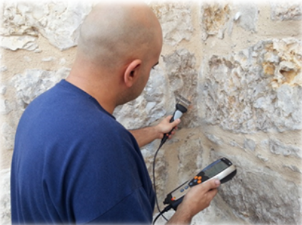
A wide range of sensors is available on the market to monitor temperature and humidity, either continuously or timely (see image). Indeed, it is necessary to know how to properly treat, interpret and integrate the data they provide.
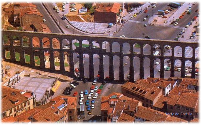
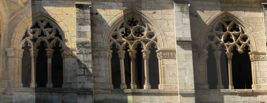
What is not so frequent is using alternative methods to evaluate the effects of moisture on the materials of the built heritage. Even before these appear and the remedy is worse than the disease. CARTIF is a pioneer in the use of laser scanners to make this assessment. A recent article published in the prestigious international journal Studies in Conservation, together with the developments carried out for the European research project INCEPTION show that while 3D documenting a historical building, the level of humidity present in a known type of material could be registered in parallel. A trustworthy 2×1 to take into account in the minimum conservation expenditure times we live in. The cloister of the Cathedral of Ciudad Rodrigo (Salamanca, Spain) has been the choice for on-site validations.
An important example that gives account of the scope of applied research in cultural heritage by a technology centre within a sector where it still takes more than expected that not so new technologies to be of daily use.
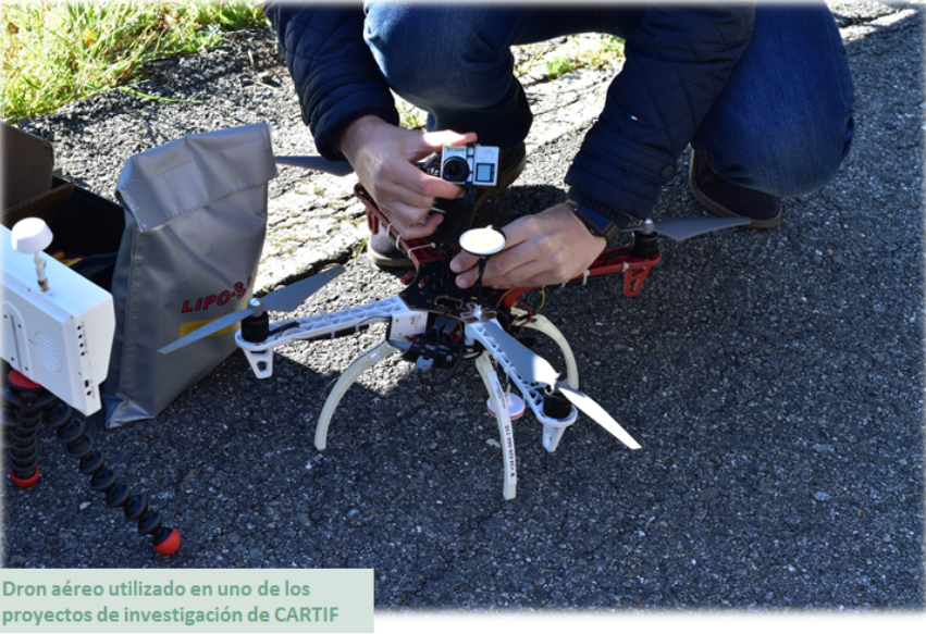
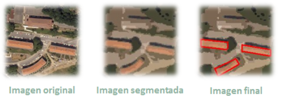
As you know, drones are becoming more and more used nowadays. The main reason is the decrease in its price. Therefore, taking aerial images using drones is more competitive than using other devices, such as planes, helicopters or satellites. This also allows ad-hoc measurement campaigns to be carried out, instead of using images from a data base, so the use of more detailed images are made possible.
But, what is aerial photography and how does it work? Aerial photography is not only the process of taking photographs from the air, but also the treatment of these images. There are many variables involved in an aerial acquisition, which must be considered to ensure that the data is useful enough to obtain the desired results.
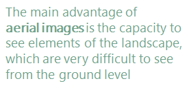
The main advantage of aerial images is the ability to see elements of the landscape, which are very difficult to see from the ground level.
Aerial photographs are taken in two basic forms, oblique or vertical, and both have different uses and applications.
Oblique: These images are usually taken at an angle, typically 45 degrees, but they can be whatever angle that gives the best view of the photographed area. The oblique image is primarily used in archaeology to take a wider context of the supervised zone and the area around it, and also to give depth. Nearly always they are taken at a much lower elevation than when are taken in vertical and its application is fairly limited as they often only work for a specific purpose. These images are taken from small fixed aircrafts, such as drones, and are perfectly suited for monitoring erosion of features and monuments over time.
Vertical: Taking a zenithal photograph over a landscape is the more usual form of aerial photograph. It is a plan view, so there is no perspective to distort the image. This also means that it is difficult to read the features of the photographed area, such as changes in height.
Applications of Aerial Photography
In Archaeology: Aerial photography is ideal for locating lost monuments, especially those that are not visible at ground level, those that are under the soil and cannot be seen on a field walk and those that can only be seen under certain conditions.
In Agriculture: Crop field reports and statistic can be delivered for farmers using multispectral image data from special devices, such as thermal cameras. CARTIF has a lot of experience using this type of devices in some R&D projects (more info).
In Climate Change studies: It’s possible to detect rivers which are drying up, the reduction of inland lakes, forests that are dying, etc. Researchers keep vital records in changes over seasons and years to track local effects of climate change and risks to local ecosystems. Localised aerial photographs are fundamental for that purpose.
In Other Earth Sciences: They can also be used to study the process of natural changes, such as variations in soil and geology over time as well as changes to the underlying ground that leads to disasters such as landslides.
Energy and Infrastructure: Mitigate business risks, accelerate pipeline planning, learn about surface composition, and predict environmental impact using the data from aerial images.
Engineering and Construction: From construction site selection and evaluation to the assessment of existing structures, this technology facilitates every step of the project.
Defense and Intelligence: Defense agencies, military contractors, and law enforcement are continually faced with new challenges. Aerial images provide an unrivalled advantage when planning strategic and tactical operations, carrying out combat missions, and developing simulations.
Disaster Response: When timeliness counts, image data provide crucial insight for disaster response efforts and insurance operations. CARTIF is involved in a project which uses this type of technology in order to accomplish these goals.
Urban development: High resolution Aerial Images has gained popularity among Planners, Developers and Engineers for small scale mapping for most urban and land development applications. Information from Aerial Photos when combined with GIS (Geographic Information System) mapping is amongst others, used for analysis, strategic planning and evaluation in urban planning. CARTIF has been working in a research line related to this topic for many years.
Computer-aided engineering tools (CAE) are more pervasive nowadays, and finite element analysis is having more impact than at any other time. In the past, CAE abilities have been used in specific fields with highly trained engineer teams and large computing facilities. For example, in the aeronautical industry the objective is, among others, to design more efficient airliners and the automotive industry must produce safer cars in case of accident.
Currently there are not field of science or engineering that has not been affected, and in some cases transformed, by computer simulation. Almost most manufacturing companies, regardless of the industry, can take advance of CAE abilities to simulate their process and improve their performance.
Sport industry show off this fact, for example, SPEEDO produced swimsuits including compressing effects for changing, in certain way, the shape of the swimmer’s body. Using this idea, SPEDOO designed suit able to achieve drag reductions in more than 15 per cent. In the JJ.OO. of Beijing, 94% of the medals were won by swimmers dressed with SPEDOO swimsuits (Michael Phelps, Mireia Belmonte …) and 23 out of 25 Olympic records where beaten using this technology (according to data from FINA).
For an airliner or for an Olympic swimmer the engineering problem is essentially the same. There is a shape moving through a fluid and the drag must be minimized. That is, advanced engineering aerodynamic concepts also works in the textile industry. This example clearly defines the current situation of CAE abilities, where high technology is used to solve what we could define as trifling problems.
According to Lesa Roe, NASA Langley Research Center director, “Modeling and simulation is older than NASA”. Since the first models of digital calculators, computing machines evolved step by step and around year 2000 some experts believed that engineering simulation programmes had reached its peak due to the big improvement in abilities for the limited supply of high-level engineers.
However, the more powerful computers and the friendly integrated analysis environments have allowed companies to take advantage of the enormous potential of simulation programmes to make accurate predictions about natural phenomena, providing compelling evidence that we are really gaining in our understanding of how the products, processes and services can be optimized. Therefore, the almost endless engineering simulation techniques provide big growth opportunities, based on the current needs and the challenges that this poses.
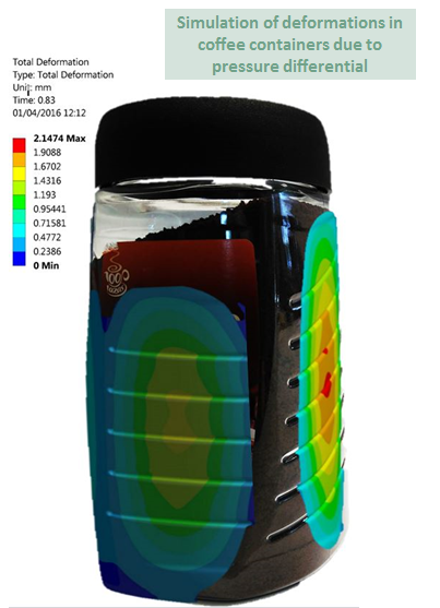
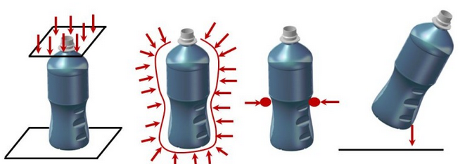
As the saying goes, “Necessity is the mother of invention” CARTIFbelieves and works in endless possibilities to help customers develop better products and processes. I would like to stress in a particular application: the estimation of the static and buckling behaviour of very thin walled containers for food packaging.
Through simulation programmes we are able to detect weak points and design failures prior to manufacture, with consequent savings in time, material and money. Note that the containers are manufactured by plastic injection machines using expensive cast moulds. During the analysis are taken into account parameters such as constitutive material properties (PET, HDPS, aluminium …), thickness, type of liquid or granular product to be content, etc. that define the containers and allows us to predict its performance, resulting in deformation curves under load, loads of collapse, tensions and stretching under certain loads which it may be subjected to circumstances of the production process, storage and transport conditions, including temperature, pressure and impact effects among others.
Beside theses services, being aware that “data is the new currency”, CARTIF is also working on structural health monitoring in civil structures. The aim of this work is predict when maintenance will be needed or what the expected behaviour of structure should be if the real system begins to deviate from the digital models’ behaviour. This idea can be reviewed in my previous post ‘When structures age’.
Public initiatives like ‘Connected Industry 4.0’ are developing measures that allow the industrial fabric to benefit from the intensive use of ICT in all areas of its activity. These initiatives are linked to the term Industry 4.0, which refers to the challenge of carrying out the 4th Industrial Revolution through the transformation of industrial sector by the enabling technologies incorporation: 3D printing, robotization, sensors and embedded systems, augmented reality, artificial vision, predictive maintenance, cybersecurity, traceability, big data, etc.
Construction sector, as the industrial one, is immersed in a deep metamorphosis before the irruption of these new technologies. The economic crisis has been very intense in this market. As a strategy for its recovery, it must its particular revolution, taking full advantage of the opportunities offered by enabling technologies. For this reason, the ‘Construction 4.0’ concept appears as a necessity to digitize the construction through the incorporation of enabling technologies adapted to their particularities.
In this sector, it is the first time that a revolution is built ‘a priori’, which gives us the opportunity both to companies and to research centres to participate actively in the future.
In CARTIF, we work along this line by means of some projects that apply these technologies. In the case of the BIM (Building Information Modeling), which proposes to manage the complete cycle of the project through a digital 3D model, we develop improvements to include all the actor of the value chain.
With reference to 3D printing, a methodology that allows the construction of objects layer by layer, obtaining singular pieces or with complex geometries, CARTIF applies technologies to the direct printing on vertical surfaces for the rehabilitation of facades.
If we talk about robotization, besides the fact that making specific robots to certain tasks, adapt existing machines increasing their autonomy and safety of operators. In this line, we collaborate to develop monitoring and navigation technologies for the automatic guidance of machinery and to detect risks situations between machinery and operators.
With all these innovations, the future of construction is promising, if and when this research would be considered as an essential basis for its growth.