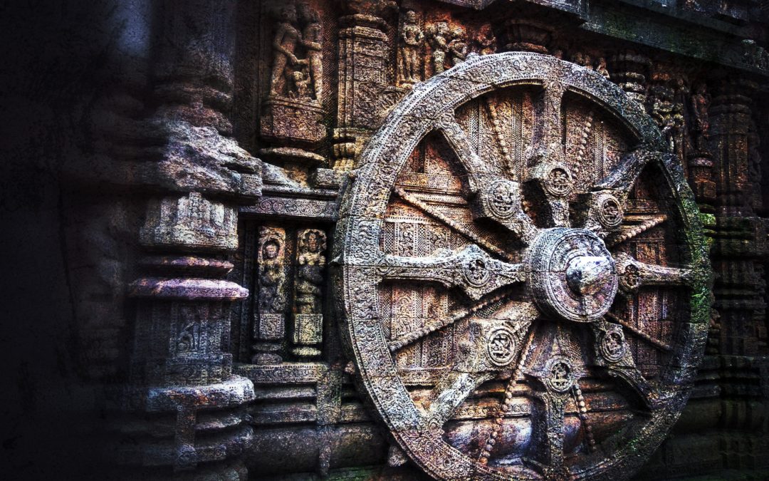
It is said that those who forget their own history are condemned to repeat it. Cultural Heritage is part of that history, talks about our beliefs and experiences, it carries us where we came from and grants our identity. Knowing it helps us to understand the problems of the present and preserving it is essential to ensure the new generations can continue learning from it.
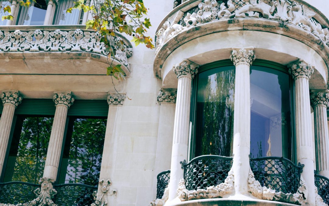
Historical building is the wider and most significant cultural heritage set transferredup-to-date, bringing together immovable assets (the buildings themselves) and movable assets (what these contain) of great interest. Therefore, if we want to conserve our heritage we must keep historical building in the finest possible condition. This way we will guarantee its physical integrity and ensure that it can continue to be used by residents and visitors.
Since 2012, conventional buildings in Spain have undergone a periodic inspection known as ITE (Technical Building Inspection), similar to the Vehicle Inspection Test but applied to buildings. This inspection evaluates the adequacy of the assets to the required conditions of safety, healthiness, adornment, habitability, accessibility, use and services, and it applies to buildings older than 50 years with preferably residential use.
So, if buildings from 50 years ago are being inspected, shouldn´ t those built 500 years ago also to be inspected?
The reality is that, as it is raised right now, the conventional inspection is not applicable to historical assets. First, because of the regulation framework, which makes it mandatory in municipalities with a population higher than 25,000 inhabitants, a case that does not represent the built heritage, mostly found in rural areas with a significantly lower population. Secondly, beacause heritage buildings are very rarely used for residential purposes (even in urban areas), and, if so, it tends to occur in fully rehabilitated or newly-built annexed areas, adapted to the uses and customs of the 21 st century. But, above all, the application of the conventional inspection to historical buildings is not feasible because it is obvious that conventional and historical buildings present great construction, materials and use differences, consequently, it must be a specific inspection to verify how they are, just fitting the uniqueness and sensitivity that cultural heritage demands.
This is the origin of the ITEHIS project, which studies the applicability of innovative technologies to the technical inspection of historic buildings older than 100 years, provided with a specific use and subject to be classifiable into one of the major architectural groups: civil, military, religious or industrial. In other words, ITEHIS aims to adapt the already existing buildings inspection to the exceptional features and endless architectural, constructive, functional and aesthetic variations that can be found in historical buildings, also considering the movable assets they contain (organs, altarpieces, stalls, collections,etc.). This is also tight to the broad context od the digitization of Heritage, bringing together all the aspects inspected through HBIM (Heritage-BIM), which we already talked about in a specific post called “The BIM approach: fitting to Heritage?”. Once the inspection is concluded, a report will be delivered, providing improvement measures rating the historical building from 1 to 5. This will allow not only to evaluate its condition, but also to objectively prioritize the resources needed to its conservation. Furthermore, ITEHIS will help to lay the foundations of a specific regulation to guarantee the sustainability of historical buildings through the Spanish Standardization Committee.
ITEHIS, project financed with FEDER funds through the Instituto de Competitividad Empresarial (ICE), is another example of collaboration between a technology centre such as CARTIF and companies committed to Heritage snd the territory they are settled (TRYCSA, ALTEISA and ACITORES), which intend to contribute to those proper conservation through new, more effective ways, so that we can continue knowing, using, enjoying and, ultimately, learning from it.
The word “Digitization” is ubiquitous today. The term is extremely used but its meaning is worn out when taken to a specific terrain. Answering to how?, with what?, for what?, and even, why? for the particular case of Cultural Heritage it is not an easy taks, nor closed. Digitization and Heritage is a Romeo and Juliet style romance (to make a cultural simile), where the respective families view the matter with suspicion, even when it is destined to be a well-matched marriage, not one of convenience.
Digitization sounds technological, state-of-the-art. Heritage sounds archaic, old-fashioned. Putting one together with the other, and avoiding formal definitions (otherwise non-existent), it is proposed to define digitization in this case as the incorporation of digital technologies (those based on electronics, optics, computing and telecommunications) to the products, processes and services that organizations follow and offer for research, protection, conservation, restoration and dissemination of Cultural Heritage.
Digitization affects the way of facing work, the proper way of working and the organization in itself, modifying its structure and managing. This alteration in the organization schema causes an atavistic fear of losing the artisan and professional-knowledge supported value that features the companies in the Cultural Heritage sector, made up of more than 90% by SMEs in the EU. This is the real reason why they take the longest to “digitize”. It is not just an issue about buying, installing and operating computers, software and wireless networks. The change is deeper: it is not a question of appearance; it is a fundamental question. But it is well worth remembering that the workshops and people who appear in history and arts books today because the works they have bequeathed, are indeed famous for having innovated and used the best technologies available on their time.
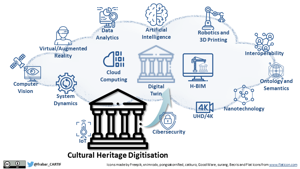
But, what are the technologies at stake today for the Digitization of Cultural Heritage? Without being exhaustive, and also being aware of leaving things in the pipeline, the most demanded technologies are summarized below:
Multidimensional modelling and simulation (including Heritage BIM -HBIM[1]-): exact 3D virtual replicas of movable and immovable assets; mechanical, electrical, acoustic, lighting and signal coverage simulations with specialized software; 4D (evolution in time). The HBIM parametric modelling is remarkable to complying with Directive 2014/24/ EU and also to addressing extra dimensions: 5D (costs); 6D (sustainability and energy efficiency); 7D (maintenance).
Sensors, Internet of Things (IoT) and 5G: multipurpose devices for capturing, combining and communicating all kinds of data over the Internet. The 5G allows making between 10 and 20 times faster the traffic of these data compared to current 4G mobile communications. These technologies are typically used in structural and environmental monitoring for condition assessment.
Data analytics to get useful information: cloud computing (to archive all kind of information and making it accessible and searchable from anywhere and from any device connected to the Internet); edge computing (local computing -on the axis-, to improve response times and save bandwidth); big data (massive treatment of structured and unstructured data – in the order of Petabytes: 1015 bytes-). The determination of causes and effects, together with the prediction and characterization of behaviours (including visitor flows) are common examples
Artificial intelligence (AI): machine learning (ability to learn without specific coding) and deep learning (learning based on neural networks that mimic the basic functioning of the human brain) are well-known. One example is the Gigapixel technology to enlarge images to see tiny details thanks to intelligent computer processing of extremely high-quality photographs. Another example is the automatic recognition of symbols or animal species in a prehistoric rock engraving on which a-priori nothing can be distinguished.
Systems dynamics and informational entropy: they are ways of studying adaptive mechanisms in complex and changing systems (such as all those that humans forge -which are precisely characterized by creativity and culture-) to make predictive models or to support decision-making and management.
Computer vision: capturing and processing of images by cameras that operate in one or more spectral ranges to see beyond our eyes also at all scales (from space with COPERNICO satellites, to the microscopic world): search for patterns, detection of pests , humidity, alterations, irregularities and falsifications, definition of authorship and artistic techniques, conservation assessment. Applied to video analytics, it is very effective in guaranteeing the security against theft, vandalism or looting.
Digital twins: combining some (or all) of the previous aspects (multidimensional modelling, simulation, computer vision, sensors, IoT and AI) upon a virtual replica ready to remotely work under a multidisciplinary approach, allows to anticipate possible problems and experiment safely before performing any intervention, helping to its optimal planning. It can be applied to movable assets, but it has special significance in immovable ones.
High-quality audio and video: Hi-Res for audio and FullHD, 2K and 4K for video are words already entered in our lives. They allude to the highest attributes and durability of the audio and video formats that can be used for the registration of intangible heritage or the broad dissemination of heritage in general.
Virtual reality (VR), augmented reality (AR) and mixed reality (XR): to recreate spaces, decorations and configurations, past or future, even to look into planned interventions upon 3D models using special glasses or smartphones.
Ontologies and semantics: to uniquely name and hierarchically structure the constituent elements of movable or immovable assets and cultural landscapes so that they are understandable both by specialists and laymen regardless of their language and cultural background.
Interoperability: to synchronize data, systems and processes nevertheless of their origin and format.
Cybersecurity: to defend against malicious attacks on computers, servers, mobile devices, electronic systems, networks and data. Blockchain allows avoiding falsifications as well as guaranteeing the authorship and the digital visa of projects.
Robotization and 3D printing: configurable robots (adaptable, shippable and remotely-assisted) allow the modular construction of specific elements in-situ. They also allow the automation of inspection, cleaning, assembly, conservation and restoration processes in dangerous or hard-to-reach places, quickly and accurately. It can be combined with 3D printing for sealing, insulating and watermarking in different materials and finishes. Particularly 3D printing allots functional replication (total or partial) at different scales to create prototypes, parts, mock-ups and test series.
Nanotechnology and new advanced materials: the continuously increasing processing power of computers and their combination with the hardware of machinery allows the study and manipulation of matter in incredibly small sizes (typically between 1nm and 100nm), resulting in a wide range of materials and techniques usable in conservation and restoration.
In March 2021, the European Commission published a report that reviews and evaluates the actions and progress achieved in the EU in the implementation of the Recommendation (2011/711/EU) on digitization, online accessibility and digital preservation of cultural heritage as one of the main political instruments in those matters[1]. The ecological and digital transitions are, in fact, the keys to the agreement on the so-called Recovery Plan for Europe[2]. EU Member States have agreed on the need to invest more in improving connectivity and related technologies to strengthen the digital transition and emerge stronger from the COVID-19 pandemic, transforming the economy and creating opportunities and jobs for that Europe into which citizens want to live. During the confinement society has shown that Cultural Heritage in digital format was a true social balm, with museums and collections open online 24 hours a day.
Thus it is the right time and there are no general solutions for “digitization”. Cultural Heritage is not about producing thousands of cars, parts or packaging per day. Quite the contrary: each company, each project, each asset must be considered for what it is: something unique. To make a clear example, imagine somebody getting into the supermarket and asking ‘what is there to eat?’ The answer, consonant with the perplexity, could be: there are from precooked to fresh, meat, fish, eggs, dairy and sweets in all possible varieties. It depends on your culinary tastes, your hunger and the time you have, your nutritional needs, the time of day … In short: particular problems require particular solutions.
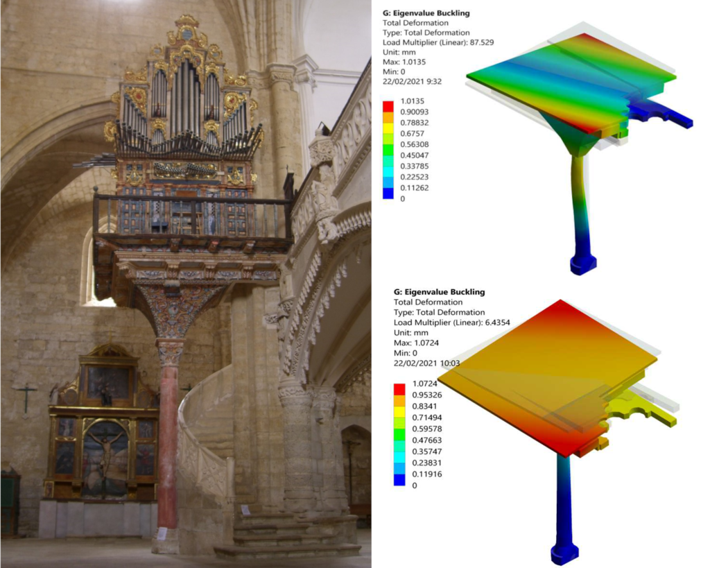
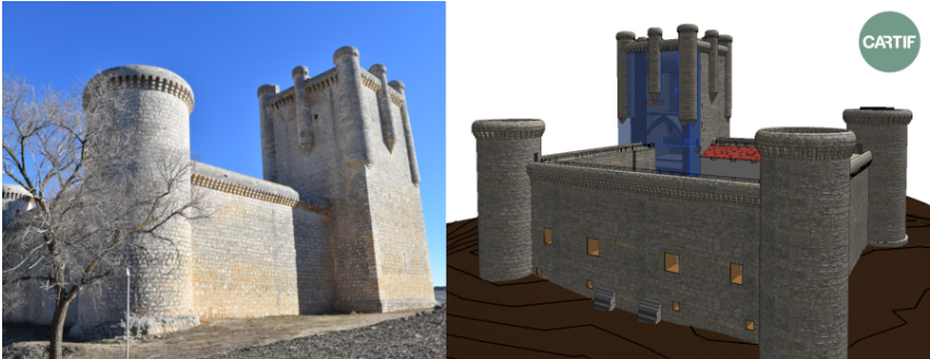
The BIM approach (Building Information Modelling) is all around Architecture, Engineering and Construction professionals, but when it comes down, very few companies are founding their daily work on this paradigm and applications are really far from being homogeneous. BIM is many times (let’s say “usually”) incorrectly identified as a specific software package or a type of 3D digital model. However, BIM is much more than a newer version of CAD or a 3D visualisation tool.
The BIM approach provides a digital featuring of a building or infrastructure throughout its whole life-cycle, adding extra information to help making better and more-timely decisions upon a 3D model that allows a multidimensional analysis: 4D (evolution); 5D (costs); 6D (sustainability -including energy efficiency-); 7D (maintenance).
Although there is still a lack of knowledge on how BIM and associated digital innovations are applied across European countries, the European Directive 2014/24/EU imposes BIM Level 2 for government centrally procured projects. Level 2 refers a collaborative process of producing federated discipline specific models, consisting of 3D graphical data (those visually represented) and semantic data (those significant additions) as well as associated documentation (for instance: master plans). Information is exchanged using non-proprietary formats, such as Industry Foundation Classes (IFC).
Consequently the built heritage is subject to BIM for the purposes of documentation, conservation and dissemination, but the distinctiveness and sensitivity to meet heritage demands requires technological and methodological particularizations leading to the concept of Heritage-BIM (H-BIM). The purpose of H-BIM is to provide a 3D parametric model as a “container” of information generated all over time by different procedures, by different people, and from different sources (hw & sw). The model would capture the multidisciplinary nature of Heritage, far away from the simplicity and modularity of conventional construction, and would be very useful to study, evaluate the state of conservation and plan interventions on the assets in a profitable way. It is quite a challenge for a sector where digitization is a pending issue.
This technologically means facing many challenges, starting with the minimum amount of graphical and semantic data that would be adequate to support the activities of the sector. Two of the most important are:
The combination of 3D data with different types of images (thermography, high resolution photographs or multispectral recordings) to produce a really useful H-BIM model for exhaustive assessment.
The photorealistic texturing of 3D models for a rigorous representation of reality.
Both aspects are being worked by CARTIF to decisively help companies, managers and public administrations in the digitization of Cultural Heritage.
In two previous posts [When the Historic Buildings Talk (I) and (II) apart from making clear the importance of the conservation of the built heritage as long as describing the environmental factors that influence such conservation, we have already faced the temperature and the humidity as the two key factors to be monitored. Anyway, and in case you forgot about it, there are other aspects that also must be monitored to avoid deteriorations resulting in expensive and time consuming restorations:
Lighting (natural and artificial).
Pollutants.
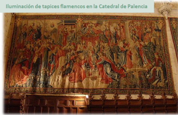
In this post we are going to get involved with lighting, which mainly affects the movable goods that decorate or treasure the historic buildings. Be patient, pollutants are left for the next (and last) delivery.
Illumination can be of natural origin (coming from the sun) or artificial (coming from electrical sources), but in any case is an electromagnetic radiation that covers three ranges: infrared (IR), visible (VIS) and ultraviolet (UV). We usually call “light” the visible part to human eyes. UV radiation has a smaller wavelength than VIS and is the one with the highest associated energy. IR radiation has a longer wavelength than VIS radiation and is less energetic. Both UV and IR radiations are not necessary “to see”, but they do influence the deterioration of the materials.
When a work of art is illuminated, whether it is a painting, a polychrome, a tapestry or a parchment, the whole range of radiation (IR, VIS and UV) is absorbed by the materials of which it is composed. This radiation is associated with energy capable of altering and degrading the molecular structure of many materials, especially the most “perishable”, such as those of organic origin (textiles, pigments, leather and paper).
The UV component (highest energy), is the one with the greatest capacity to alter the materials, disintegrating and weakening, producing their yellowing. The VIS component is able to decolorize the most sensitive pigments. On the other hand, the IR component produces a heating effect that accelerates certain chemical reactions.
Thinking about this, it seems that for the assets we keep in museums, churches, hermitages, castles, palaces, archives and libraries, it would be best to preserve them in the dark. However, for study, conservation, and especially for exhibition purposes, some kind of illumination is required. Following the criteria of the IPCE, which establishes the Spanish National Preventive Conservation Plan (PNCP), these are the parameters to evaluate the risks derived from illumination:
Intensity of artificial and natural sources.
Exposure time to the illumination.
Spectrum (range) of emission of the artificial light sources, knowing if they emit in not-visible radiation bands.
Incidence of natural illumination, its orientation, and whether the radiation is direct or diffuse.
What lighting control measures exist on-site.
In turn, the assessment of the damage caused by lighting must take into account the following aspects:
Since this damage is cumulative, we should flee from high levels of illumination, but maintaining a commitment for adequate vision. By giving concrete values: 50 lux for the most sensitive materials and 150-200 lux for medium-sensitivity cultural assets.
Damage is determined by the amount of illumination, i.e. the intensity of illumination during the time an asset is exposed (lux / h). Thus, keep in mind that the damage in the case of high illumination levels with short exposures would be the same as with low levels and longer exposures.
The degradative effect of lighting also depends on other environmental factors such as humidity and air pollution.
Therefore, where we place our cultural assets, how natural light affects them, and with what kind of lamps we focus on, are critical aspects for their proper conservation (see Figure). CARTIF offers advice and tailored solutions based on a proven experience of more than 20 years in applied research to Cultural Heritage.
The importance of the train from an economic point of view is beyond dispute. It emerged as one of the most extraordinary innovations in the Industrial Revolution, because although it is true that the first steam locomotives had already been created before, it was during this period when the potential of this new means of transport could be seen.
Over the years, it has become one of the preferred means of transport for citizens, because of its safety and speed, only surpassed by the airplane. Furthermore, in contrast to the use of private vehicles, rail service contributes to fuel economy per passenger and is therefore more sustainable than other means of transport.
According to data from ADIF (Administrator of Railway Infrastructures), in Spain a train passenger consumes 5 times less litres of petrol equivalent per kilometre than traveling by car, and 20 times less than traveling by airplane. Or, for example, transporting one tonne of goods by rail consumes 4 times less litres of petrol equivalent than by road, and 1,380 times less than by air.
But, what about the construction of the railway infrastructure necessary for the movement of trains? Is it sustainable?
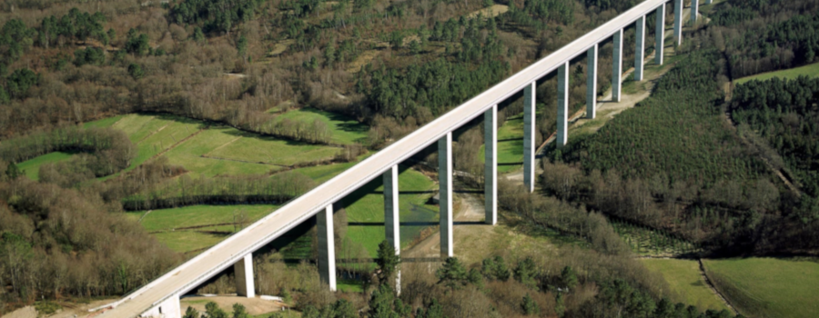
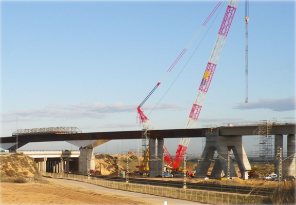
This was the premise of the LIFE HUELLAS project, led by CARTIF, together with the companies Vias y Construcciones and IK-Ingeniería and the University of Granada. Its objective was to improve the construction process of railway tracks in terms of their environmental impact, with special emphasis on those aspects that affect climate change.
It should be borne in mind that the railway infrastructure is made up of civil works such as bridges, viaducts, tunnels and service roads, and of the superstructure, made up of rails, sleepers, fastening material, and electrification, signalling and track safety installations. The production, construction and maintenance of all this infrastructure has a high environmental impact.
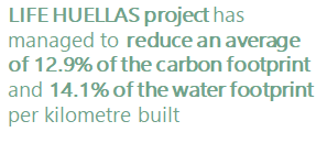
The LIFE HUELLAS consortium considered that life cycle assessment techniques, combined with intelligent data analysis, could help reduce the carbon and water footprint of railway infrastructure works by 10% and 5% respectively.
After four and a half years of intensive work, the project has managed to reduce an average of 12.9% of the carbon footprint and 14.1% of the water footprint per kilometre built in the works that have been used as pilots, i.e. better results than expected. Quite a success.
The project began with an exhaustive collection of basic information to analyse the environmental impact of the construction of railway networks, based on previously identified variables. Later, participating companies focused their efforts on studying the transformation of environmental impact into carbon and water footprints, through the development of a consolidated assessment methodology.
From this compilation, a smart tool will establish different planning alternatives applying computational intelligence techniques and showing specific values of footprint and previously selected environmental indicators. That is to say, the objective is to help in the decision-making process during the planning phase of the works.
Furthermore, the research team has developed a free online tool that provides a detailed environmental diagnosis of the processes involved in the construction of this type of infrastructure. This tool, available on the project website www.life-huellas.eu, allows the development of railway projects with not only economic, but also environmental and social criteria.
For the development of both tools, the consortium has exhaustively studied more than 460 project units and a collection of relevant sustainability variables and indicators, grouped in:
Environmental indicators: carbon and water footprint, acidification potential, photochemical oxidation and eutrophication.
Social indicators: improving working conditions, health and safety, human rights, governance, community infrastructure and job creation.
Economic indicators: project costs.
Tests were carried out during the demonstration phase of the project in two real works; on the one hand, the Ponte Ambía (Orense)-Taboadela (Orense) section of the Madrid-Galicia high speed line for the track infrastructure, that is for the earthworks (embankments, trenches, tunnels, etc.) and for the factory works (bridges, drainage, viaducts and level crossings); and on the other hand, the Antequera (Málaga)-Loja (Granada) section, for the track superstructure over which the trains run, whose main elements are ballast, sleepers, rail, electrification and signalling.
With the aim of contributing to these processes in terms of sustainability, the consortium has compiled in a guide of Good Practices the main conclusions of the experience acquired during the development of the project, as well as the different sustainable alternatives proposed.
Although LIFE HUELLAS project has already been completed, railway works on which it has been validated have effectively reduced the carbon and water footprint of their construction phase, contributing to the environmental improvement.
In addition, free access to the calculator will remain available at www.life-huellas.eu for anyone to use. You can also find us at networking and dissemination events, transferring gained knowledge, since the objective now is to promote replicability by communicating obtained results to other companies and sectors. For example, many of the railway infrastructure construction operations are common to those that build other infrastructures, such as roads, so they can also benefit from the results of the project.
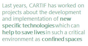
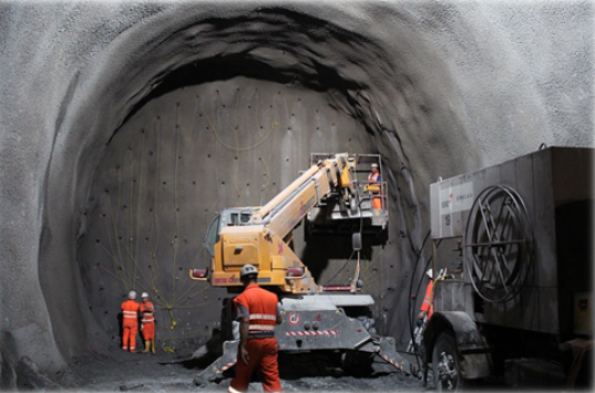
Ensuring the safety of workers inside confined spaces is a critical activity in the field of construction and maintenance because of the high risk involved in working in such environments. Perhaps it would be useful, first of all, to know what is meant by confined spaces. There are two main types of confined spaces: the so-called ‘open’ ones, which are those with an opening in their upper part and of such a depth that it makes their natural ventilation difficult (vehicle lubrication pits, wells, open tanks, tanks),…) and ‘closed’ ones with access openings (storage tanks, underground transformer rooms, tunnels, sewers, service galleries, ship holds, underground manholes, transport tanks, etc.). Workers entering these confined spaces are exposed too much greater risks than in other areas of construction or maintenance and it is therefore essential to apply extreme caution.
Each confined space has specific characteristics (type of construction, length, diameter, installations, etc.) and specific associated risks, which means that they require solutions that are highly geared to their specific safety needs.
The ‘conventional’ risks specific to confined spaces are mainly oxygen suffocation, inhalation poisoning of pollutants and fires and explosions. But new ’emerging’ risks from exposure to new building materials such as nanoparticles and ultrafine particles are also emerging. In addition, as research into new materials improves, there is also a better understanding of their potential negative effects on human health and how to prevent them.
The truth is that the training of workers and current safety regulations seek to anticipate risk situations before they occur in order to avoid them and thus prevent the appearance of accidents. But several problems arise: on the one hand, the regulations are not always strictly observed (whether due to workload, carelessness, fatigue, etc.) and on the other hand, there are always inevitable risks. In the case of carelessness, systems can be proposed to minimise this type of error and in the case of risks that cannot be avoided, systems can be proposed to detect them early and plan the corresponding action protocols.
It should be noted that risk situations do not usually appear suddenly and in most cases are detectable in time to avoid personal misfortunes. There are several problems: the detection of these risks is usually done with specific measurements using the portable equipment that the workers must carry, many times the workers are not controlled to access the premises with the corresponding protection equipmente and almost never a continuous monitoring of the indoor atmosphere is done.
In recent years, new technologies and equipment have been developed that can be applied to improve security in this type of environment and reduce the associated risks.
In this type of environment, an effective risk prevention system should be based on technological solutions capable of providing answers to safety aspects throughout the entire work cycle in confined spaces: Before entering the space itself, during all work inside the enclosure and when leaving the work space (whether it is at the end of normal work or by evacuation).
The latest confined space air quality monitoring systems are based on multisensorial technology that combine different detection systems to ensure the best possible conditions to avoid or reduce the risks present in the confined spaces.
Advanced data processing techniques (machine learning, data mining, predictive algorithms) are also being applied, enabling much more efficient and rapid information extraction.
In the same way, great advances have been made in access control and personnel tracking systems, allowing us to know the position of each worker and even his or her vital signs in order to detect almost immediately any problem that may arise.
Finally, it should be noted that the use of robots and autonomous vehicles (land and air) equipped with different types of sensorization are increasingly being used to determine the conditions of a site before it is accessed. This is especially useful in those where there may have been an incident: power failure, collapse, fire,… or simply because environmental conditions are suspected to have changed and the reason is unknown.
CARTIF has been working on these issues for many years now, both in safety projects in critical construction environments (PRECOIL, SORTI) and in specific systems for tunnels and underground works (PREFEX, INFIT, SITEER).
In short, the development and implementation of new specific technologies can help to save lives in such a critical environment as confined spaces.