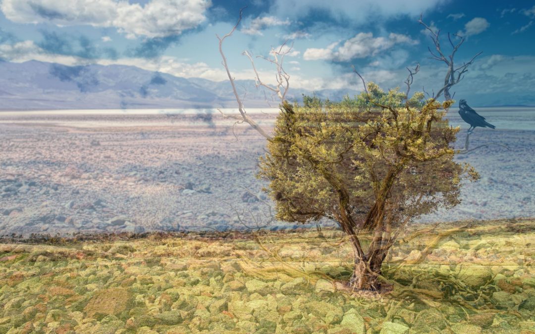
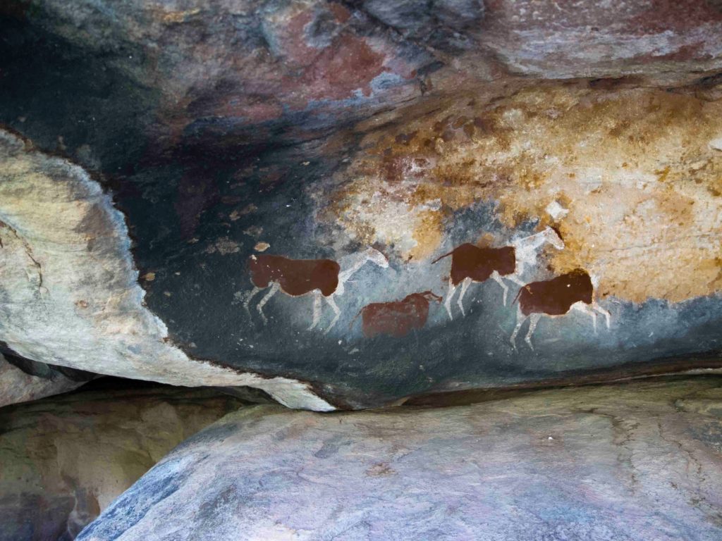
Each landscape makes specific, different, unique feelings. When contemplating a meadow dotted with trees, we do feel something totally different from what we feel looking at a desert area. This also happens when facing cultural landscapes1. A Romanesque church does not make the same sensations as the ones perceived when contemplating cave paintings.
Numerous investigations conclude that there is a significant correlation between our personality and the landscape preferences. Other research argues that the human-landscape relationship has an “innate” basis, dating back to the survival needs of primitive humans, whose environment demanded perceptual abilities and predispositions, which today- at a psichological level- are still functioning. This explains why we still prefer open and slightly flat landscapes (watching predators), in addition to vegetation and good access to water (covering vital needs).
Then, it could be argued that the affective system brought into ply in landscape appraisal is a consequence of wider individual strategies concerning the personality, innate factors and the individual´s attitude towards the world (enhanced by their experiences and the society where they live).
In other words, the landscape assessment depends on factors that are totally subjective and, therefore, difficult to quantify. So what should I do if I want to measure “what we like” about a certain type of cultural landscape?
This is where the so-called “Affective Computing” pops up, which consists on the study and development of systems and devices able to recognize, interpret and process human emotions.
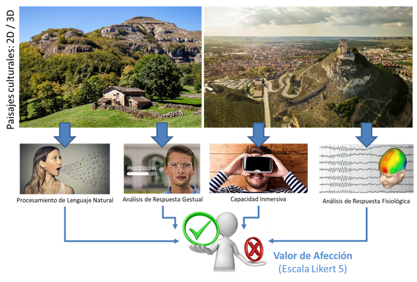
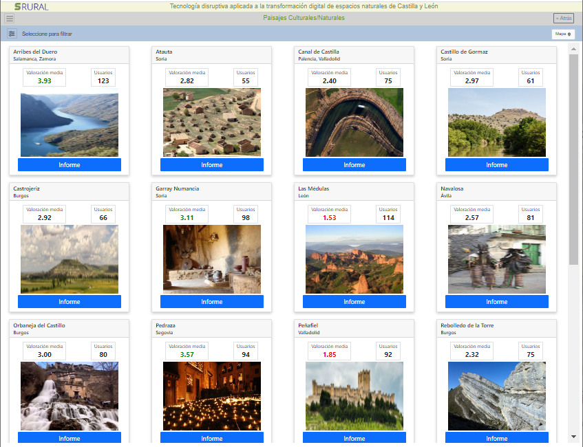
CARTIF, withinSRURAL project, is applying this set of techniques to obtain the “affection value” of any cultural landscape (“measuring how much you like the landscape”). To this ends, a cognitive system is being developed that on the one hand uses verbal language and facial expressions as input, and on the other hand, certain physiological signals (heart rate, sweating and body temperature while you are immersed into the landscape via virtual reality glasses)
All these inputs are introduced into a neural network previously trained by means of Deep Learning2 techniques to obtain the landscape´s “affection value” as useful output.
The “affection value” is very useful for decision-making by territory managers, for instance, to guide tourism promotion campaigns towards high affection values areas, but with no significant visits number. Also for profiling and segmenting tourists according to the type o landscapes they are most likely to visit, and thus to carry out targeted and more effective promotional campaigns.
It can also be used to know when it is necessary to take corrective measures or at least carry out a stud of causes in case of a tourist interesting area with a large number of visitors has a relative low affection value.
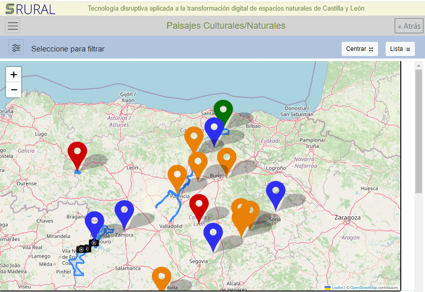
Since the decision-makers need few but very relevant information, as much graphical as possible, all kind of useful data is displayed in the most user-friendly for them y means of geolocated interfaces. Therefore, the system under development incorporates specific modules to show the information already processed, just ready to draw conclusions, which will quickly lead them to objective data-driven decisions upon Data Mining and Big Data techniques.
1 Is the landscape combining natural and cultural heritage. It has been modified by humans to be adapted to people´s needs according to their beliefs, economic activity, and the shaped society. The most obvious examples of these modifications are traditional crops, buildings and infrastructures.
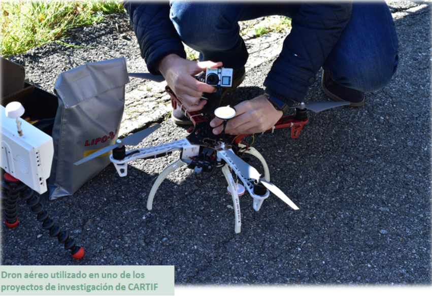
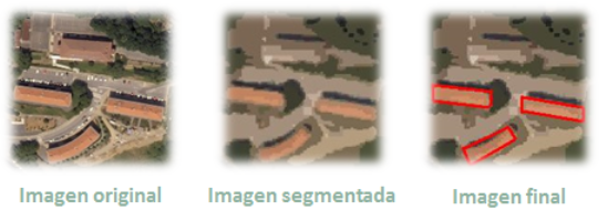
As you know, drones are becoming more and more used nowadays. The main reason is the decrease in its price. Therefore, taking aerial images using drones is more competitive than using other devices, such as planes, helicopters or satellites. This also allows ad-hoc measurement campaigns to be carried out, instead of using images from a data base, so the use of more detailed images are made possible.
But, what is aerial photography and how does it work? Aerial photography is not only the process of taking photographs from the air, but also the treatment of these images. There are many variables involved in an aerial acquisition, which must be considered to ensure that the data is useful enough to obtain the desired results.
The main advantage of aerial images is the ability to see elements of the landscape, which are very difficult to see from the ground level.
Aerial photographs are taken in two basic forms, oblique or vertical, and both have different uses and applications.
Oblique: These images are usually taken at an angle, typically 45 degrees, but they can be whatever angle that gives the best view of the photographed area. The oblique image is primarily used in archaeology to take a wider context of the supervised zone and the area around it, and also to give depth. Nearly always they are taken at a much lower elevation than when are taken in vertical and its application is fairly limited as they often only work for a specific purpose. These images are taken from small fixed aircrafts, such as drones, and are perfectly suited for monitoring erosion of features and monuments over time.
Vertical: Taking a zenithal photograph over a landscape is the more usual form of aerial photograph. It is a plan view, so there is no perspective to distort the image. This also means that it is difficult to read the features of the photographed area, such as changes in height.
Applications of Aerial Photography
In Archaeology: Aerial photography is ideal for locating lost monuments, especially those that are not visible at ground level, those that are under the soil and cannot be seen on a field walk and those that can only be seen under certain conditions.
In Agriculture: Crop field reports and statistic can be delivered for farmers using multispectral image data from special devices, such as thermal cameras. CARTIF has a lot of experience using this type of devices in some R&D projects (more info).
In Climate Change studies: It’s possible to detect rivers which are drying up, the reduction of inland lakes, forests that are dying, etc. Researchers keep vital records in changes over seasons and years to track local effects of climate change and risks to local ecosystems. Localised aerial photographs are fundamental for that purpose.
In Other Earth Sciences: They can also be used to study the process of natural changes, such as variations in soil and geology over time as well as changes to the underlying ground that leads to disasters such as landslides.
Energy and Infrastructure: Mitigate business risks, accelerate pipeline planning, learn about surface composition, and predict environmental impact using the data from aerial images.
Engineering and Construction: From construction site selection and evaluation to the assessment of existing structures, this technology facilitates every step of the project.
Defense and Intelligence: Defense agencies, military contractors, and law enforcement are continually faced with new challenges. Aerial images provide an unrivalled advantage when planning strategic and tactical operations, carrying out combat missions, and developing simulations.
Disaster Response: When timeliness counts, image data provide crucial insight for disaster response efforts and insurance operations. CARTIF is involved in a project which uses this type of technology in order to accomplish these goals.
Urban development: High resolution Aerial Images has gained popularity among Planners, Developers and Engineers for small scale mapping for most urban and land development applications. Information from Aerial Photos when combined with GIS (Geographic Information System) mapping is amongst others, used for analysis, strategic planning and evaluation in urban planning. CARTIF has been working in a research line related to this topic for many years.
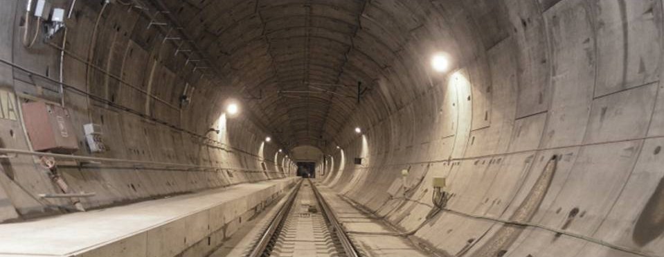
What is the use of 3D digitalization of infraestructures? Inspecting coatings, detecting cracks, inventorying and sensorization of tunnels and other structures. In the following video, we explain you what we do in CARTIF:
David Olmedo and José Llamas, researchers of CARTIF.
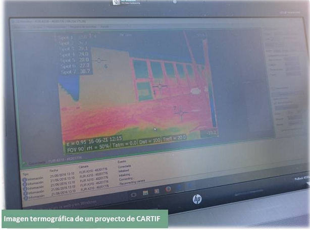
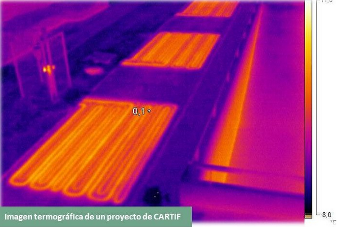
Everybody knows what a thermographic camera is. Movies as “Predator”, the formula 1 broadcast, etc. have helped people to know this technology. CARTIF has been using it, during last years, in construction and infrastructure inspection.
My intention is not to tell you again, what everyone already knows, but talking about some myths and misconceptions that people have regarding its use.
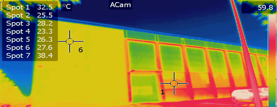
Thermography is based on that any object with a temperature above zero kelvins emits infrared radiation, which is not visible to the human eye. This radiation depends on the object temperature, thus knowing the said radiation; it is possible to obtain the temperature.
A thermographic camera not only acquires this radiation (emitted radiation), but also the reflected and the transmitted radiation. Moreover, there are other parameters beyond the object temperature involved, so the temperature determination is not easy.
Thermographic camera have software which is able to calculate the object temperature in a transparent way to the user. If the operator relies too much on the said software and he doesn’t know well what he is doing, then issues might appear. A non-experienced operator may make some mistakes. In this post, we would like to clarify some misconceptions about thermography that general public has:
1. Thermal imaging cameras can see below the surface of a target. FALSE. The camera only sees the surface of a target and calculates the temperature
2. All types of materials can be easily measured with thermal imaging cameras. FALSE. The temperature information is given in the emitted radiation, but the imager also “sees” the reflected and transmitted components. Most materials are opaque to infrared, so we can usually ignore the transmitted energy. However, many materials (with low emissivity) reflect infrared radiation, thus these materials are difficult to be measured using a thermal camera.
3. Thermal imaging cameras should never be used in the daylight. FALSE. Infrared thermal imaging cameras do not detect visible light. They are only sensitive to infrared radiation, but it is easier to control reflected radiation at night, so it is advisable doing thermal inspection during that period of time.
4. Knowing the emissivity of the inspected object is not necessary. FALSE. This is the most important factor the camera must know to correctly calculate the temperature.
2. Detection of tiny motors in pro cyclist bikes Femke Van den Driessche, one of the favorites at the Under-23 Women’s World Championships in Belgium, was found to be racing with a mechanical motor this past January by the UCI. This is known as the first mechanical doping in cycling history.
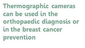
3. Orthopaedic diagnosis Researchers at UPM confirm the usefulness of infrared thermography (IRT) for detection and early diagnosis of orthopaedic injuries.
A research group of Thermography Unit from the Faculty of Sciences for Physical Activity and Sport (INEF) at Universidad Politécnica de Madrid (UPM) in collaboration with CEMTRO has carried out a study to establish the capacity of infrared thermography (IRT) to discriminate injuries and to evaluate its applicability in emergency trauma scenarios.
Results show that this technology is a great support tool to correctly identify the presence or absence of injuries in a particular body part.
4. Pest control Some tests have concluded that it is possible to use thermography in order to pest detection, due to the correlation between the presence of insects and humidity. Furthermore, some anomalies detected on thermal images might be caused by some insects such as termites.
5. Breast cancer prevention using thermography This method is based on detect temperature changes in thermal images. Cancer creates blood vessels when it starts to develop. This process, which is known as angiogenesis, produces heat, so a thermal camera could detect this heat long before cancer can develop.