
Have you ever wondered how it is decided when a road or a tunnel should be repaired? The most common is that an operator notes damages down in his notebook while he goes walking, and then, these annotations are used to determine the state of the infrastructure. Operators often walk on the hard shoulder, while traffic circulates normally around them, with the corresponding threat to themselves and to users of the road. This task is really monotonous and repetitive, resulting in eyestrain that difficult to obtain an acceptable degree of reliability in the inspection. Furthermore, although the visual inspection adapts well to new situations when it is performed by human operators, it has a high degree of subjectivity, which causes that two different operators, or the same operator on different times, could provide different results.

The implementation of new technologies to perform these inspections can reduce the risks described, get objective results, increase the speed of inspection and make these data digitally available. In brief, working conditions of operators and the quality of the results are improved.
Among the different variables that are required to be measured in road infrastructure it can be found surface deterioration. To measure this deterioration is necessary to analyse the visual appearance of the surface. The technology that allows us to obtain this information, as you can imagine, are the cameras. But we must keep in mind that these surfaces have some quirks that do not allow us to obtain the desired results using conventional cameras.
Such surfaces are defined by having a limited width and indeterminate length but much greater than its width, so they could be considered continuous surfaces. The images of these surfaces should be taken in motion and as fast as possible in order to make the acquisition efficiently. To do this, although it would be possible to use area-scan cameras, it is much better to use linear camera. A linear camera builds the images capturing them line by line, and therefore a continuous image in the forward direction is constructed. The camera consists of a linear sensor, which is usually between 512 and 12,000 pixels. For capturing the object, it has to move relative to the camera, or the camera must move relative to the object.
The main advantage of using linear cameras is that it is only necessary to illuminate a thin line of the object to be inspected. As a result, the amount of energy required is reduced drastically and it is easier to illuminate homogeneously the area to be inspected. The lighting of a line is done primarily through LED light sources that focus light through optical in a desired line width. To achieve this, the lighting system must be at the proper distance from the object to be inspected and must be aligned with the camera sensor accurately. Laser illumination sources are also very effective, with the advantage that concentrate the light at any distance. Finally, incremental encoders are used to synchronize the acquisition of each image with the displacement of the surface to be inspected relative to the camera. Incremental encoders generate a pulse each time the inspection vehicle moves forward a certain distance, indicating the camera the exact moment for acquiring the line image.

Having the images of the surface to be inspected available is itself extremely useful for the infrastructure manager. However, what really gives added value to the inspection system is the automatic interpretation of images. You must remember that the ultimate goal is to detect damages on the surface and classify them by its type. Often, it is difficult to automatically differentiate defects from areas without deterioration and, moreover, defects of the same type have a very uneven visual appearance.
In order to process the images successfully, complex image processing techniques have been developed characterizing anomalies in the space-frequency domain.
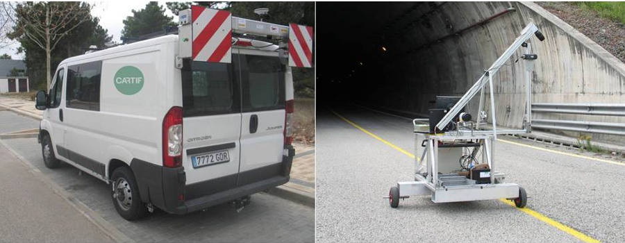
CARTIF has collaborated with companies from the construction industry to address the inspection of this type of surfaces in several research projects. In one of them, it has been developed an inspection vehicle for detecting road surface deterioration. Furthermore, it has also been developed a platform for inspecting the surface of tunnels. Similar techniques also have been applied to the inspection of industrial products that fall within the definition of continuous surfaces, such as coils of cold rolled steel.
In all cases, the results of the inspection are displayed to the end user, so that appropriate decisions can be taken and, most importantly, it can be determined when the infrastructure has to be repaired.

Industrial Engineer, Ph. D. He has wide experience in RTD projects involving sensing, computer vision, 3D reconstruction and distributed computing.
- Machine vision for quality control - 14 March 2017
- Automatic visual inspection of linear infrastructure - 14 April 2016