Land use planning key in the ecological transition
Climate change and environmental degradation represent one of the greatest threats, not only in the European Union, but in the world. In fact, the UN Secretary-General Antonio Guterres stated that “the climate crisis is a code red for humanity and consequently an urgent and coordinated climate action is needed before it is too late”. This entails work on defining effective adaptation and mitigation strategies towards a climate neutral and resilience society, overcoming the current silo approach in favour of a systemic one for evaluating impacts, risks and interactions of climate change across sectors or systems (e.g. Climate, Energy, Land systems).
A system consists of “an integrated set of interrelated elements that works together and interact within a complex socioeconomic framework” (Hoffman and Wood 1976). In particular, the land system (terrestrial component of the Earth system), recently recognised as a “planet boundary” at risk of being exceeded, is the result of human interaction with the natural environment, so that it encompasses all processes and activities related to the human use of land, including socioeconomic, technological and organizational investments, as well as the benefits gained from land (e.g. food, materials, energy, households, etc.) and the unintended social and ecological impacts of societal activities, as for instance, the biodiversity degradation or the energy poverty among others.
In recent years, land system science has moved from a focus on observation of change and understanding the drivers of these changes to a focus on using this understanding to design sustainable transformations through stakeholder engagement and through the concept of territorial and land use planning. So that, it is clear that a better understanding of drivers, state, trends and impacts of different systems helps to reveal how changes in the land system affect the functioning of the socio-ecological system as a whole and the trade-off these changes may represent. Therefore, thanks to the interrelation among land system and the rest the critical systems on fighting the climate change, land use planning is appointed as key even critical tool in the ecological transition.
As you might imagine, Land use planning is not a new concept, regulating land use may have originated about 4,000 years ago in the mud brick cities of Mesopotamia, however from 1980s onwards, Land use planning practises shifted towards an integrated and participatory approach, involving planning experts, decision-makers and citizens.
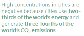
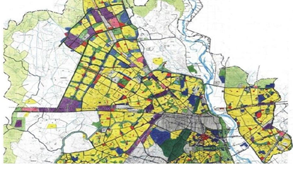
Especially relevant in the ecological transition, is the planning of land uses in urban areas, since cities dynamics consuming unlimited resources (cities account the 75% of the natural resources consumption), is unsustainable and exceeds the capacity of some essential variables of ecosystems.
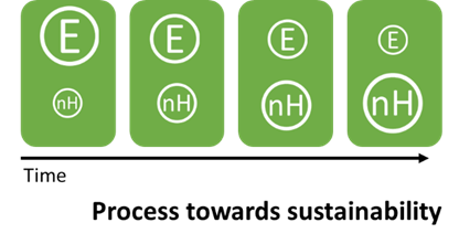
Salvador Rueda1, proposed to consider the city as an ecosystem (formed by interrelated elements among which there are biological organisms), evaluating the efficiency of such ecosystem as the relation between the consumption of resources (E), the number of urban legal entities (n) (economic activities, institutions, facilities and associations) and value of the diversity of legal entities, also called urban complexity (H).
According to this, efforts in cities planning should be focused on establishing a new urban model following the principles of ecosystemic urbanism: improving urban compacity and complexity in its land use organisation, ensuring an efficient use of resources (urban metabolism) and ensuring a greater social cohesion.
In CARTIF, we work on the development of models (at different scales) tools and solutions to support this systemic approach in the transition towards a sustainable use of land, so as to guide decision making Land Use Planning processes and the holistic evaluation of adaptation and mitigation solutions. For instance, in the eParcero project we work to support territorial and land use planning by identifying plots with potential for specific land uses (e.g. industrial development, energy production, etc.), while in the RENERMap project we are developing models for the identification of plots with renewable energy potential (e.g. wind, solar or geothermal energy) that contribute to the decarbonisation of the energy system of our region, through the integration of geospatial climate, environmental and social data in the territorial planning.
Specifically, the RethinkAction project (GA 101037104) coordinated by CARTIF, aims at delivering an Integrated Assessment Platform to simulate and evaluate land use-based solutions at local, EU and global scales over time (2050 and beyond). At local level, a methodology to develop dynamic models in the 6 case studies (representative examples of climate change impacts and land system pressures) will be delivered, by using dynamic modelling methods such as System Dynamics (SD) or Agent-Based Modelling (ABM) along with GIS tools.